Geological Remote Sensing Group
ارائه خدمات تخصصی سنجش از دور و اکتشافات معدنیGeological Remote Sensing Group
ارائه خدمات تخصصی سنجش از دور و اکتشافات معدنیCAE Datamine Studio 3.21.7164.0
نرم افزار CAE Datamine Studio 3.21.7164.0 محصول بخش مهندسی معدن کمپانی CAE است. این نرم افزار یک نرم افزار پیشرو جهانی برای صنایع مرتبط با منابع طبیعی با بیش از 45 مرکز در سرتاسر جهان می باشد.
جدیدترین نسخه نرم افزار ESRI ArcGIS

ESRI ArcGIS for Desktop 10.3 این برنامه یکی از محصولات معروف شرکت ازری آمریکا هست که در زمینه سیستم های اطلاعات مکانی کاربرد دارد .نرم افزارArcGIS نرم افزاری بسیار آسان برای کاربردهای GISاست که به کاربران این امکان را می دهد که به سادگی اطلاعات مکانی و داده های توصیفی را برای ایجاد نقشه ها ، جداول و نمودارها به کارگیرند و به عبارت دیگر ArcGis نرم افزاری است که اجازه ساخت یک سیستم کامل اطلاعات مکانی را فراهم می کند.این نرم افزار شامل ابزارهایی برای برنامه سازی ، ایجاد نقشه ها و مدیریت آنها ، سرور برای پشتیبانی در سطح سازمان و پشتیبانی از سیستمهای موبایل و بیسیم است . این نرم افزار ابزارهای لازم برای جستجو ، تحلیل داده ها و نمایش نتایج را با کیفیت مناسب در اختیار کاربران قرار می دهد .
لینک دانلود نرم افزار ArcGIS 10.3
برای دانلود روی لینک بالا کلیک کنید
Autodesk AutoCAD Map3D 2016
Autodesk AutoCAD Map3D 2016 نرم افزار دیگری از شرکت مشهور و مطرح Autodesk در زمینه
طراحی و مدیریت پروژه های ساختمانی و راه سازی می باشد و برای طراحی و
ترسیم نقشه های ساختمانی و سازه ها و همچنین در صنعت راه سازی به کار می
رود.این نرم افزار در واقع بر روی پلت فرم نرم افزار بسیار معروف و قدرتمند
AutoCAD ساخته شده است و امکان دسترسی مستقیم برای طراحی ٬ رسم و عملیات
های مربوط به سازه ها را فراهم می کند.به کمک این ابزار می توانید برای رسم
و طراحی انواع ساختمان ها ٬ پروژه های برقی ٬ زمین های مسطح و پروژه های
ساختمانی که فونداسیون آنها در آب قرار دارد استفاده کنید.این نرم افزار
همچنین قابلیت اتصال به آخرین نسخه از برنامه AutoCAD را نیز دارد.
برای دانلود روی این عبارت کلیک کنید
نسخه جدید نرم افزار Global Mapper
Global Mapper 18.0.0 Build 092616 x64 / x86
نرم افزار Global Mapper یکی از برنامه های پرکاربرد در علوم نقشه برداری و GIS است.نرم افزار Global Mapper به شما امکان مسیریابی و مشاهده نقشه ها بصورت سه بعدی را می دهد. می توانید با استفاده از آن ، نقشه ها را بصورت رایگان از ماهواره ها دانلود و ذخیره نمایید. امکان تعیین موقعیت مکانی شخص حامل دستگاه جی پی اس نیز از جمله دیگر قابلیت های نرم افزار است.
منبع: www.softgozar.com
لینک دانلود نرم افزار(کلیک کنید)
New in v17
Significant New Features
Dramatic Speed Improvements - depending on data and machine anywhere from 5 to 10 times faster for all types of data processing and rendering
New Cartographic Map Publishing tool including:
A paper scale interface that actually lets you see the layout in the paper proportions
Easier addition of overlays for graphics, text, legend, scale bar, north arrows etc, and positioning these elements through click and drag
Template creation and template library
New flexible view interface with dock-able windows and multiple map views for better data visualization and manipulation
Several new built-in online sources, including US National Map sources (w/ 1 foot color imagery source), World Navigation Charts (1:1M Scale ONC Charts), and Australian water sources
New support for CPT palette files, both for layer color palettes and for initializing elevation shaders and updated support for PLY, PNG (added EXIF tag support), Sketchup, CPT and USGS Earth Explorer formats
Updated logging information now available for scripting, along with many other scripting enhancements
Speed improvements and threading updates for many large format raster and vector data types
Updates to GPS Tracking, to support Glonass and Baidu NMEA positions, as well as new tracking functions to follow the live position more closely and orient the map to the GPS Heading
Added new GPS toolbar buttons to control whether or not the main display centers on the GPS vessel location and automatically rotates to keep the GPS heading towards the top of the display
Attribute Calculation now stores the previous formula for new attributes, if one exists, so that a user can have see what changes a previous formula made to an attribute .Added a new right-click option on the Feature Vertex dialog so you can easily duplicate vertices for an area feature. This allows you to use the "Pen Up" draw mode option to turn off the drawing of some segments of the area border
LiDAR
Automatic classification and extraction for power lines and noise points
Dramatic speed enhancements for LiDAR and other Point Cloud data for drawing, gridding and load
Updated building and vegetation classification
Fast spatial thinning and threading for very large datasets
Calculation of basic rooftop statistics from point clouds
D updates
Dramatic 3D display speed optimizations
Support for using custom 3D models symbol styles for any point feature in the 3D window for example graphically pleasing tree models for extracted trees
Export of 3D data formats, including PLY, OBJ, and Collada (DAE), and STL
Reference: http://www.bluemarblegeo.com/products/global-mapper-new-features.php
پایگاه اطلاعات نشریات کشور
پایگاه اطلاعات نشریات کشور
magiran.com پایگاهی مرجع است که با هدف اطلاع رسانی و دسترسی به همه مجلات و نشریات علمی کشور راه اندازی شده است.
برای ورود به این پایگاه روی لینک زیر کلیک کنید
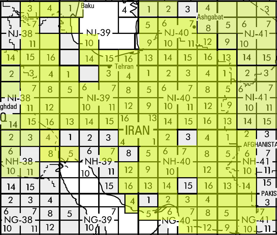
دانلود نقشه های توپوگرافی
دانلود نقشه های توپوگرافی ایران در 120 شیت با مقیاس1:250.000
( منبع:وبلاگ دانشجویان ژئومورفولوژی آزاد نور geomorphology.blogsky.com )

کتاب شیمی تجزیه دستگاهی
دانلود چاپ دوم کتاب بسیار خوب شیمی تجزیه دستگاهی Chemical Analysis: Modern Instrumentation Methods
and Techniques

فهرست این کتاب عبارت است از :
PART 1 SEPARATION METHODS
۱ General aspects of chromatography
2 Gas chromatography
3 High-performance liquid chromatography
4 Ion chromatography
5 Thin layer chromatography
6 Supercritical fluid chromatography
7 Size exclusion chromatography
8 Capillary electrophoresis and electrochromatography
PART 2 SPECTROSCOPIC METHODS
9 Ultraviolet and visible absorption spectroscopy
10 Infrared spectroscopy
11 Fluorimetry and chemiluminescence
12 X-ray fluorescence spectrometry
13 Atomic absorption and flame emission spectroscopy
14 Atomic emission spectroscopy
۱۵ Nuclear magnetic resonance spectroscopy
PART 3 OTHER METHODS
16 Mass spectrometry
17 Labelling methods
18 Elemental analysis
19 Potentiometric methods
20 Voltammetric and coulometric methods
21 Sample preparation
22 Basic statistical parameters
دانلود کتاب: دانلود با لینک مستقیم
پسورد فایل فشرده : alivechem.com
حجم فایل : ۱۰٫۷MB
منبع :
www.alivechem.com

GeoScienceWorld
GeoScienceWorld
روی لینک بالا کلیک کنید
A comprehensive Internet resource for research and communications in the geosciences, built on a core database aggregation of peer-reviewed journals indexed, linked, and interoperable with GeoRef